New Westminster Drive Road Rehabilitation and Improvements Project
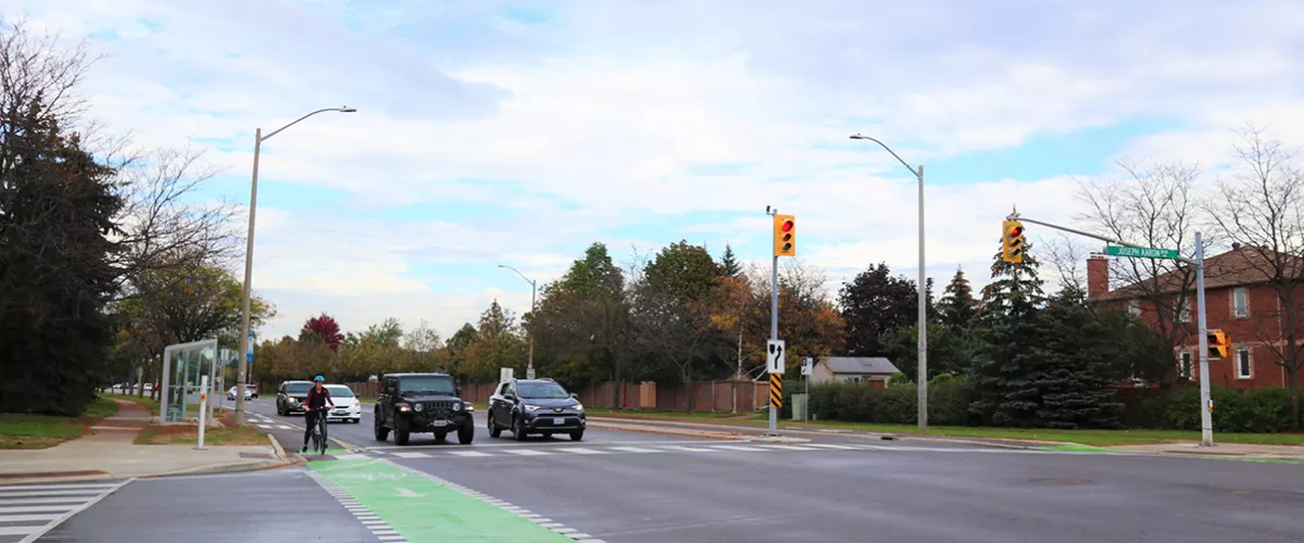
Improvements are coming to New Westminster Drive for all road users – drivers, transit riders, cyclists and pedestrians.

Image
Image is of New Westminster Drive and how it currently looks. Image features cycle tracks and street traffic.

Work includes:

  • road resurfacing.
  • a new signalized mid-block pedestrian crossing.
  • upgrading existing lighting infrastructure. 
  • replacing sidewalk segments and upgrading crossings to meet accessibility standards.
  • upgrading 10 transit stops with new bus pads.
  • upgrading existing signalized mid-block pedestrian crossings. 
  • upgrading two signalized intersections.
  • construction of new in-boulevard cycle tracks.
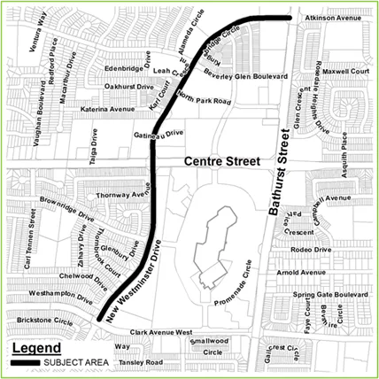
 

These upgrades will be made to approximately two kilometres of road, from Bathurst Street to Clark Avenue. These enhancements will further complement the overall active transportation network within the city and enhance pedestrian safety and accessibility. Construction will begin by the end of September 2023 and is anticipated to be complete by the end of 2024. 


This project supports the City’s commitment to improve transportation and mobility, foster sustainable communities and create an active, safe and diverse city – all priorities highlighted in Vaughan’s strategic plan. 


Project Map

Image
Map image of New Westminster Drive, and where the road improvements will span from.


Join the conversation

Citizens were invited to review a video presentation that explained the background of the project, project benefits and outcomes, corridor improvements, construction scope and timelines and more until February 2023. Thank you to those who reviewed the online presentation and provided feedback directly to the project team. Responses to the questions received during the comment period are provided below. 


Frequently Asked Questions

Answer

The intersection of New Westminster Drive and Bathurst Street is a regional intersection serviced by York Region. Modification of the curbs is not part of this project's scope. That said, this intersection was recently widened and improved as part of York Region Transit’s VivaNext Bus Rapid Transit (BRT) Project. If you have questions about the VivaNext BRT project, you can contact the Community Liaison

Answer

Yes, the City is currently working on the design of raised cycle tracks on a segment of Atkinson Avenue.

Answer

There are approximately 280 metres between Beverley Glen Boulevard and Katerina Avenue and about 250 metres between Katertina Avenue and Centre Street, which meet the minimum requirements for a signalized crossing. In addition, there are about 125 metres from the proposed pedestrian signal at Centre Street and New Westminster Drive and the plaza entrance, which provides queuing space for about 40 cars (20 per lane). The signal would only be activated when a pedestrian wants to cross New Westminster Drive. There will be a short red light cycle (about 30 seconds) followed by a green light cycle to clear traffic on New Westminster Drive. The signalized intersection at Centre Street will also provide gaps in traffic for right-turning motorists to exit the plaza.

Answer

The City only has jurisdiction over the location of the N Park Road sign and it is currently placed in the correct location – on the stop sign – as per the Ontario Traffic Manual. The City doesn’t install signs on private property due to the liability associated with unknown underground infrastructure and any incidental construction damage.

Answer

Sidewalks are continuous through driveways and cyclist crossings have enhanced signage and pavement markings at driveways. At intersections, separated crossrides (for cyclists) and crosswalks (for pedestrians) will be provided. The turning radius for vehicles will be reduced to slow down turning motorists. Raised crossings are not a City standard.

Answer

The City has reviewed the signal timing and traffic operations in the area and at this time changes are not recommended. Signal timings may be revised in the future as conditions change.

Answer

As part of this project, the City will upgrade ten transit stops with new bus pads. These transit stops have been designed to accommodate shelters and benches. York Region Transit is responsible for installing shelters and benches and they will decide whether this infrastructure is warranted based on their policies and criteria, such as usage. Please reach out to York Region Transit customer service for any requests. They can be reached at transitinfo@york.ca or at 1-866-668-3978.

Answer

Overall, lane widths will be reduced to accommodate the new cycle track. Therefore crossings will be shorter and safer. New Westminster Drive is a bus route, which dictates how narrow the lanes can be. Where feasible, the lane width will be reduced to meet the City's standard of a minimum 3.5 metre curb lane to accommodate buses and 3.3 metre inside lane. This is included in the proposed design.

Answer

The cycle tracks on New Westminster Drive will be constructed in phases. The City is currently designing the next phase of the rehabilitation of New Westminster Drive, which will include cycle tracks to Steeles Avenue.

Answer

Thank you for supporting cycling infrastructure on New Westminster Drive. There are plans for a future cycle track on Highway 7 from the Metrolinx bridge to Centre Street, including some areas around the intersection. Please see the image below. For more information on upcoming cycling projects and plans, you can visit vaughan.ca/cycling

Image
Aerial image of Highway 7 between Bowes Road and N. Rivermede Road. In the eastbound lane, a cycle track is proposed between the bridge west of Bowes Road and N. Rivermede Road – however, cycle tracks will not be installed on the bridge east of Angelo’s Garden Centre. In the westbound lane, cycle tracks will begin east of N. Rivermede Road and stop at the same bridge. Cycle tracks are also proposed on N. Rivermede Road in the southbound lane between Langstaff Eco Park and the Highway 7 intersection.
Answer

Cycling facilities along Atkinson Avenue between Bathurst Street and Clark Avenue are currently in the design phase. These cycle tracks will connect to the newly renovated Garnet A. Williams Community Centre and will provide a connection between the Clark Avenue and Bathurst Street cycle tracks and rapid transit.

The City has also initiated the detailed design of cycling facilities along New Westminster Drive south of Clark Avenue and Hilda Avenue. The goal is to create a connected cycling network in the Thornhill community, as recommended in the City’s Pedestrian and Bicycle Master Plan. Many of these projects will be delivered in conjunction with other road, transit and watermain improvements, and construction will be phased to minimize impact on the overall area.  

Answer

There are two types of intersections included in the cycle track design on New Westminster Drive, similar to Clark Avenue. In general, at intersections with local or minor roads, such as Beverley Glen Boulevard, cycle tracks will ramp down to the road level, and cyclists will travel across the intersection with motorists. At intersections with larger roads that have higher traffic volumes, like West Promenade, the current approach is to direct cyclists into shared space corners with pedestrians at intersections. In this design, the cycle track remains raised, and both the cycle track and sidewalk stop and merge into a shared concrete pad as they approach the intersection. Outside of the intersection, cyclists and pedestrians remain separated. This intersection design encourages cyclists to slow down and yield to pedestrians when crossing and allows cyclists and pedestrians to remain off the road while safely waiting to cross. The concrete pad also enables the City to add future cycle tracks and sidewalks on connecting roads without needing to reconstruct the intersection. 

Image
Intersection with separate crossings for cyclists and pedestrians. The cycle track continues through the intersection and runs parallel to where pedestrians would cross.

Intersection with minor or local road with separated waiting area

Image
Intersection with shared space for cyclists and pedestrians. The cycle track directs cyclists onto the sidewalk where they would wait with pedestrians for the signal to change.

Intersection with larger road with shared waiting area

Answer

Mirrors tend to provide a distorted view (e.g. objects such as vehicles are closer than they appear) and are not suited for heavy traffic areas where drivers may need to make quick decisions. Except in extreme cases where sight lines cannot be improved, the City does not install traffic mirrors at intersections. Additionally, sun glare and dust or dirt accumulation can make mirrors more of a distraction on busy roads, taking the attention of drivers/cyclists away from observing conditions directly in their path.

Answer

Traffic counts have been undertaken at 16 locations across Clark Avenue. The cycle track project included the installation of five permanent pedestrian/cyclist trackers to monitor use and inform future active transportation projects across Vaughan. These trackers have shown that there are many cyclists who use these cycle tracks. A year after the installation of the cycle tracks, the City recorded a 60 per cent increase in cycling on Clark Avenue, with an additional 14 per cent increase in year two. The City expects these numbers to increase as the cycling network is expanded throughout Vaughan. The City’s goal is ultimately to move people not just vehicles, as driving is not an option for up to 30 per cent of Vaughan's population – and cycling facilities are among the most efficient uses of space to do so. By making efforts to support a variety of mobility options, the City is building a more resilient transportation system that improves access for residents of all ages and abilities.

Answer

The City does not expect to redirect the YRT bus route #3. It is anticipated that at least one lane in each direction will be open throughout construction. Bus stops will be temporarily relocated at certain times to accommodate construction in the area. City staff will monitor disruptions and communicate with the community throughout construction.

Answer

Thank you for the comments supporting cycling infrastructure on New Westminster Drive. For more information on upcoming cycling projects and plans, you can review the 2022 Active Transportation Programs Third Annual Update (PDF) and project list (PDF) or visit vaughan.ca/cycling.

Additional Resources