Stormwater Management Facility Improvements
What is a stormwater management facility?
Stormwater management facilities include wet ponds, dry ponds, wetlands, underground storage chambers and other stormwater infrastructure implemented to drain stormwater runoff.
A stormwater management facility reduces volume, flow rates and pollutants from stormwater runoff.
The City of Vaughan is committed to keeping these ponds functioning through the Stormwater Management Facility Improvements Program. Currently, infrastructure improvements are underway at various stormwater pond locations across the city.
Projects under construction
Projects listed below will be improved in 2024 and 2025 (timelines are subject to change).
These projects are partially funded by the federal government’s Disaster Mitigation and Adaptation Fund.
-
Answer
As part of the 2022 Capital Works Program, the City is improving the following outfall site in Mapes Park:
- Site 25: TRCA Outfall 28, near Brasswinds Court
Construction is anticipated to be completed by Fall 2026.
Image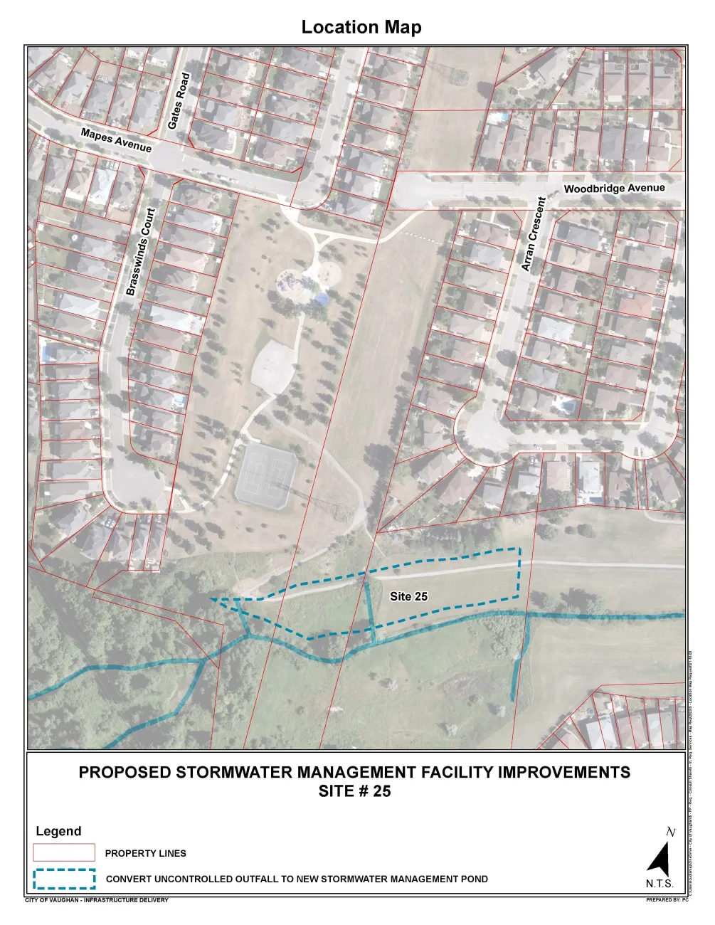
-
Answer
The City of Vaughan is improving stormwater management infrastructure at Site 23, located between Highway 400 and Four Valley Drive.
Work includes removing sediment from the stormwater management pond and upgrading maintenance access locations.
Construction is anticipated to be completed by December 2026.
Image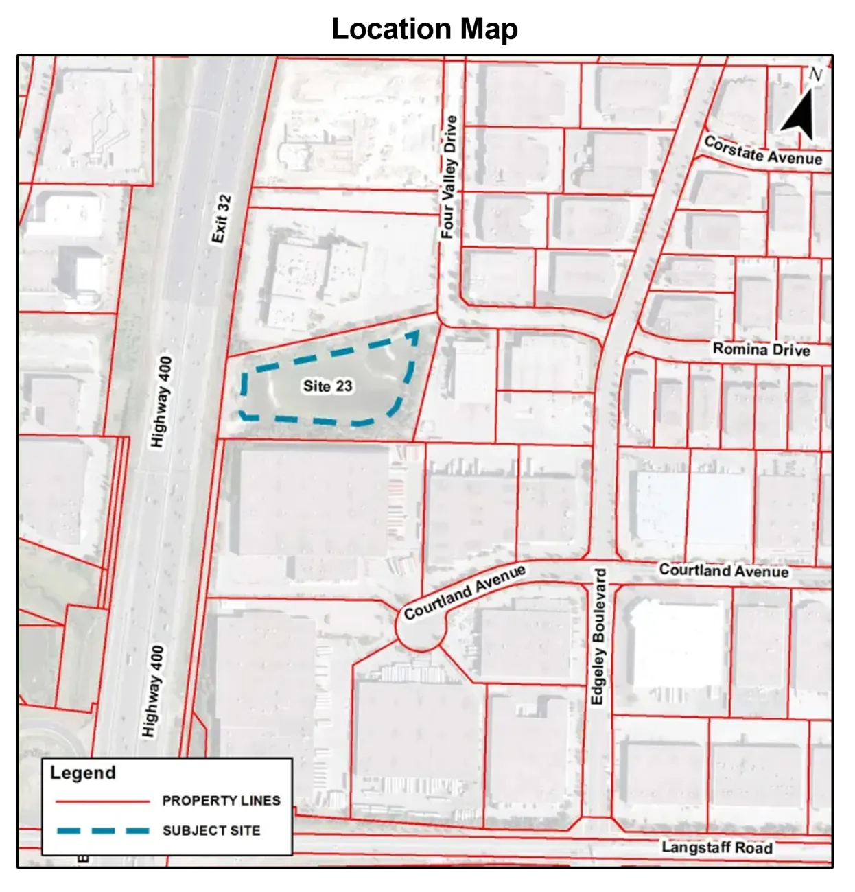
-
Answer
As part of the 2022 Capital Works Program, the City is improving Site 13, located near Woodbridge Avenue and Martin Grove Road in Rainbow Creek Park (5450 Highway 7).
Construction is anticipated to be completed by fall 2026.
Image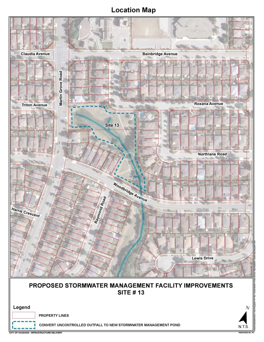
Projects under construction - UPDATES
Latest updates as of February 4th, 2026:

Rainbow Creek Park - Site 13
- Stormwater pond construction underway.
- Snow-clearing operations on local sidewalks and roadways are uninterrupted.

Mapes Park - Site 25
- Stormwater pond construction underway.
- Pathways within Mapes Park are closed during construction.
- Snow-clearing operations on local sidewalks and roadways are uninterrupted.

Four Valley Drive Pond - Site 23
- Work anticipated to start in 2026 (Q2).
Completed projects
Projects listed below are now complete.
-
Answer
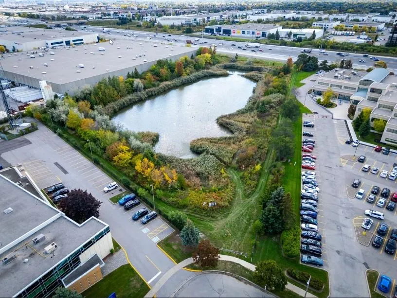
Villa Park Pond is located at the northwest corner of Villa Park Drive and Pine Valley Drive. The pond receives stormwater from two inlets – one located at the north end and the second at the northeast corner of the pond. Water is discharged to an existing outlet culvert that crosses the south end of Villa Park Drive.
Work included:
- Pond excavation to convert the facility into a wet pond and include a permanent pool.
- Realignment of existing inlet channel so it is separated from the pool.
- Installation of access roads for maintenance purposes.
- Modifications to existing outlet, including adding a low-flow structure, to increase flood control performance.
- Installation of stone inlet spillways, retaining walls and shield structures to improve sediment retention.
- Vegetation management and landscaping features.
Image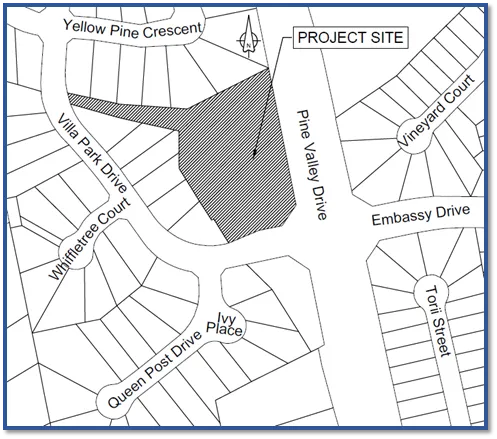
-
Answer
Accumen Investments Pond is located east of Kaiser Drive and north of the Partridge Crescent cul-de-sac. The facility provides flood control for the contributing catchment area.
Work included:
- Pond excavation to convert the facility into a wet pond and include a permanent pool.
- Installation of access roads for maintenance purposes.
- Modifications to existing outlet culvert, including adding a low-flow structure and channel to increase water quality and flood-control performance.
- Installation of stone inlet spillways and retaining walls.
- Vegetation management and landscaping features.
Image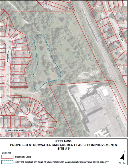
-
Answer
Harmonia Pond is located southeast of Harmonia Crescent and northeast of Dunstan Crescent. The facility provides flood control for the contributing catchment area.
Work included:
- Pond excavation to convert the facility into a wetland and include a shallow, permanent pool.
- Realignment of existing inlet storm sewer and sanitary sewer line.
- Installation of access roads for maintenance purposes.
- Installation of a low-flow outlet structure to improve flood control performance.
- Installation of stone inlet spillways, retaining walls and shield structures to improve sediment retention.
- Vegetation management and landscaping features.
Image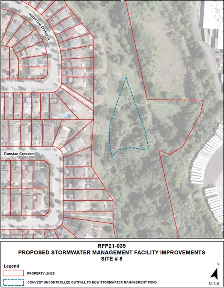
-
Answer
Saddle Tree Crescent outfall is situated to the northeast of Saddle Tree Crescent and St. Ives Court. The area is a park with open space adjacent to Robinson Creek.
Work included:
- Construction of a wetland area within the park to provide water quality benefits to stormwater prior to discharge into Robinson Creek.
- Installation of access roads for maintenance purposes.
- Installation of a flow splitter to redirect water quality flows towards the wetland.
- Installation of a wetland inlet, inlet spillway, outlet structures and outlet channel.
- Vegetation management and landscaping features.
Image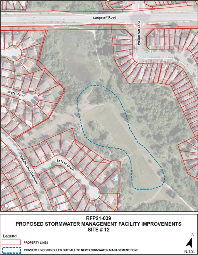
-
Answer
Upgrades to the following outfall sites in Rainbow Creek Park are now completed:
- Site 18: TRCA outfall 35, near Houston Road
- Site 20: TRCA outfall 37, near Highway 7
- Site 22: TRCA outfall 36, near Houston Road
Image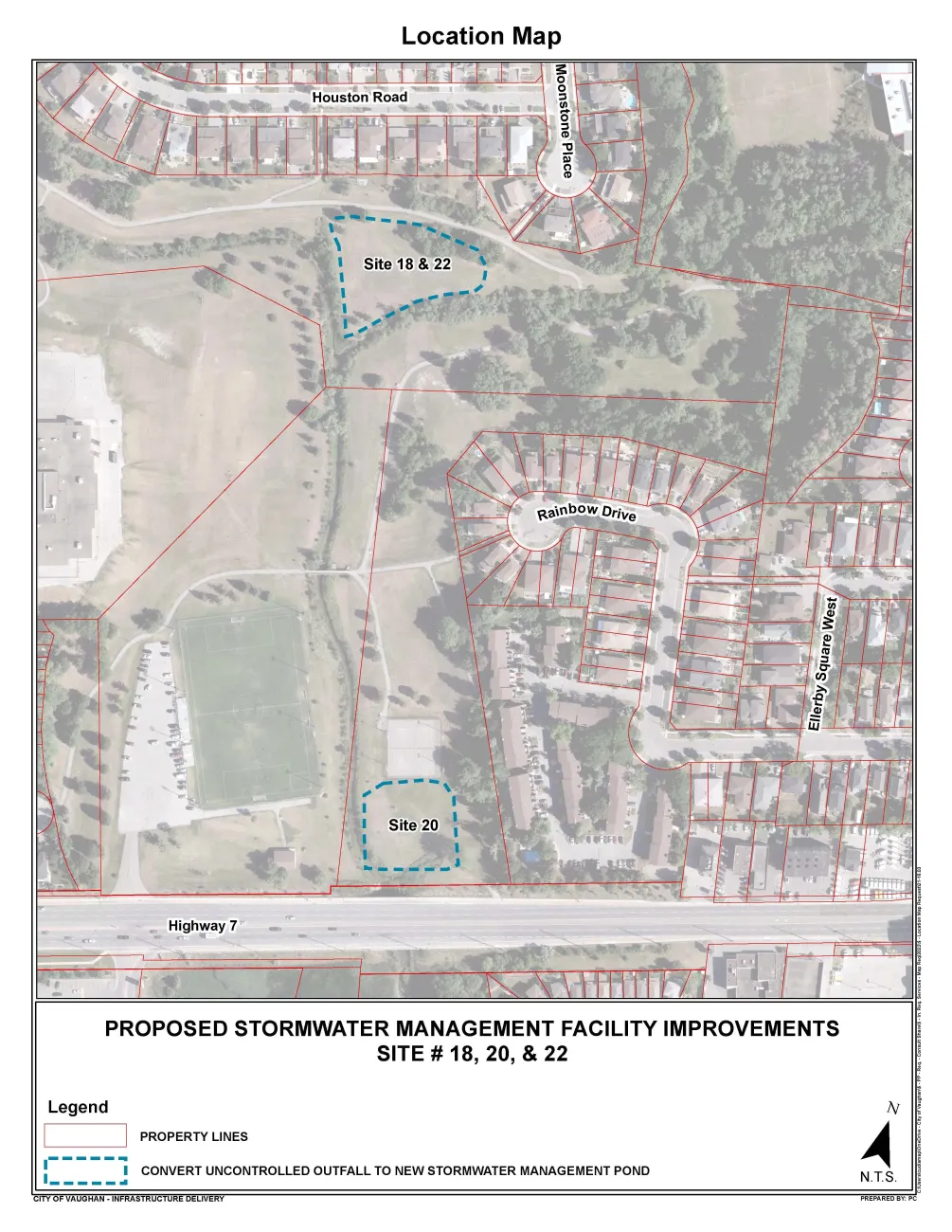
Additional Resources
PHASE 3 SITES:
TRCA Outfalls
- TRCA Outfalls 4/5 - Newsletter 1 - Aug. 2022 (PDF)
- TRCA Outfall 7 - Newsletter 1 - Aug. 2022 (PDF)
- TRCA Outfall 18.1 - Newsletter 1 - Aug. 2022 (PDF)
- TRCA Outfall 22 - Newsletter 1 - Aug. 2022 (PDF)
- TRCA Outfall 22 - Newsletter 2 - Sept. 2025 (PDF)
- TRCA Outfall 28 - Newsletter 1 - Aug. 2022 (PDF)
- TRCA Outfall 28 - Newsletter 2 - Sept.2025 (PDF)
- TRCA Outfall 32 - Newsletter 1 - Aug. 2022 (PDF)
- TRCA Outfall 32 - Newsletter 2 - Sept.2025 (PDF)
- TRCA Outfall 32 - Newsletter 3 - Nov.2025 (PDF)
- TRCA Outfalls 35, 36, 37 - Newsletter 1 - Aug. 2022 (PDF)
- TRCA Outfalls 35, 36, 37 - Newsletter 2 - October 2024 (PDF)
- TRCA Outfalls 35, 36, 37 - Newsletter 3 - April 2025 (PDF)
- TRCA Outfall 40 - Newsletter 1 - Aug. 2022 (PDF)
PHASE 2 SITES:
Villa Park Pond
- Notice of Completion (PDF)
- Project Report for Public Review (PDF)
- Project Report for Public Review (PDF)
- Notice - March 2022 (PDF)
- PIC 1 Presentation - Mar. 30 2022 (PDF)
- PIC 1 Comment Sheet - Mar. 30 2022 (PDF)
- Notice of Completion - May 2022 (PDF)
PHASE 1 SITES: