About the Weston 7 Secondary Plan
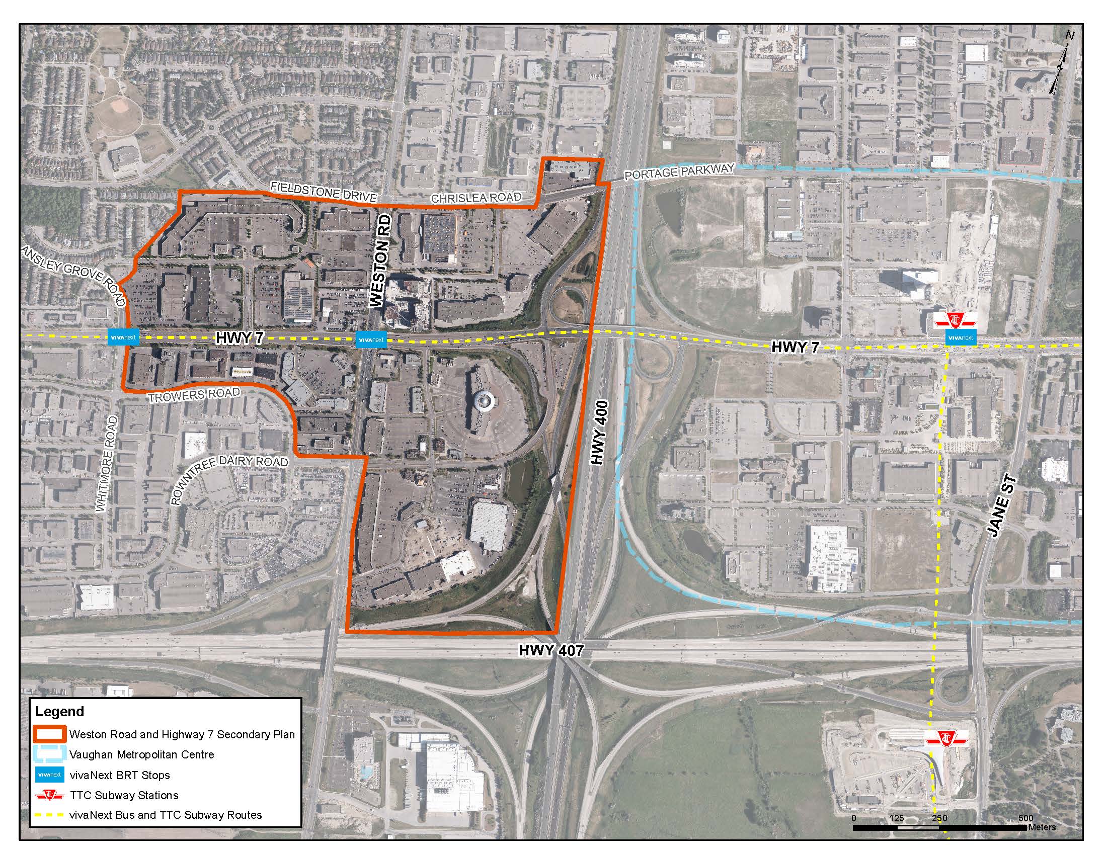
Located in Ward 3, the approximately 123-hectare study area is bounded by Fieldstone Drive and Chrislea Road to the north; the Highway 400 corridor to the east; the Highway 407 corridor, Rowntree Dairy Road and Winges Road to the south; and Ansley Grove Road and Whitmore Road to the west. The area is bisected by the Highway 7 Bus Rapid Transit and contains two Bus Rapid Transit stops. Weston 7 is located within two York Region Protected Major Transit Station Areas, being the Weston Bus Rapid Transit and Ansley Grove Bus Rapid Transit.
The Weston 7 area has historically been associated with low-density retail and commercial buildings, including big box stores, retail strip plazas and stand-alone commercial uses, supported by extensive surface parking lots. A variety of different land uses surround the Weston 7 area, including an established low-rise residential community to the north and northwest; manufacturing, industrial and other employment uses to the north, northeast and southwest; professional offices and other employment uses located along the western periphery; Highway 400 to the east; and Highway 407 to the south. The Vaughan Metropolitan Centre (VMC), the City's downtown and central business district, is located immediately east of the study area, on the other side of Highway 400.
Once complete, the Weston 7 Secondary Plan will establish a comprehensive planning and urban design framework to guide developments in the area while taking transportation, servicing, parks and open space, community service and more into consideration.
Guiding Principles for Redevelopment
The redevelopment of the Weston 7 area will be guided by the following principles:
- Recognize Weston 7 as a Vibrant Urban Community: Transform the area into an urban, vibrant mixed-use community with a distinct, definable identity and a balanced mixture of places to live, work, learn and play all served by a multi-modal transportation network.
- Support Intensification: Support new development within the area that is more dense, compact and walkable, transit-supportive and cost-effective.
- Ensure Weston 7 is a Complete Community: The Weston 7 area will be welcoming and inclusive, while providing a full range of opportunities for residential, commercial, institutional, cultural and entertainment uses and public service facilities that will be accessible to everyone.
- Provide a Full Range of Housing Options: The area will provide a mixture of housing options that will accommodate a full spectrum of households and meet the needs and requirements of future residents.
- Promote High Quality Design: The plan will ensure new developments demonstrate high-quality urban design that contributes to the recognition of Weston 7 as a beautiful and successful mixed-use urban community.
- Be a Healthy and Diverse Community: The Weston 7 area will be accessible, connected and inclusive with a diversity of mobility options and a range of housing options.
- Respond to a Changing Climate: The area will promote intensified and higher density development in support of an evolving transit system and robust active transportation network, in response to a changing climate.
- Establish Integrated Pedestrian Realm and Active Transportation Networks: Develop transportation networks that include a robust system of publicly accessible open spaces and supports an enhanced level of active transportation modes, including walking and cycling.
- Support Public Transit: Integrate transit planning with land use planning ensuring that new development supports an enhanced level of transit service over time.
- Focus the Funds Generated into Weston 7: Ensure that there is a clear recognition and response to the link between growth and the requirements for a full array of public service and cultural facilities, as well as municipal service infrastructure requirements, transportation and transit investments, and Pedestrian Realm Network improvements.
The Secondary Plan process
The plan is being undertaken through a three-phase process with comprehensive public consultation, consisting of the following:
- Phase one:
- Included a comprehensive background review, the development of a vision and guiding principles, establishing conceptual land use scenarios for evaluation.
- Phase two:
- Included preparation of a draft Secondary Plan which provides a policy framework for land uses and built form, parks and open space, supporting transportation system and servicing to support the anticipated growth and creation of a complete community in Weston 7 and held a statutory public meeting.
- Phase three:
- Will include navigating the secondary plan through the approvals process and a recommendation report to the Committee of the Whole and Council adoption.
Weston 7 Transportation Master Plan
Concurrent with the Weston 7 Secondary Plan, the City is undertaking a supporting transportation master plan study. For more information, please visit the Weston Road and Highway 7 Transportation Master Plan webpage.