About VMC Transportation Master Plan
Planning studies have been completed to support continued growth
The planned VMC road network was initially developed almost 10 years ago through the original VMC Secondary Plan (PDF) and Transportation Master Plan in 2012. Since then, transportation demands in the City and its downtown have evolved, including the opening of the VMC TTC subway station in 2017.
Making it easier to get around
While the VMC has already implemented transportation infrastructures to allow for biking, walking, public transit and ridesharing, the demand to move people and goods will increase through future development within the area. The future vision for transportation in the VMC is defined in the VMC Secondary Plan (PDF) and is centred around being transit-oriented, walkable and accessible in this area of continued growth.
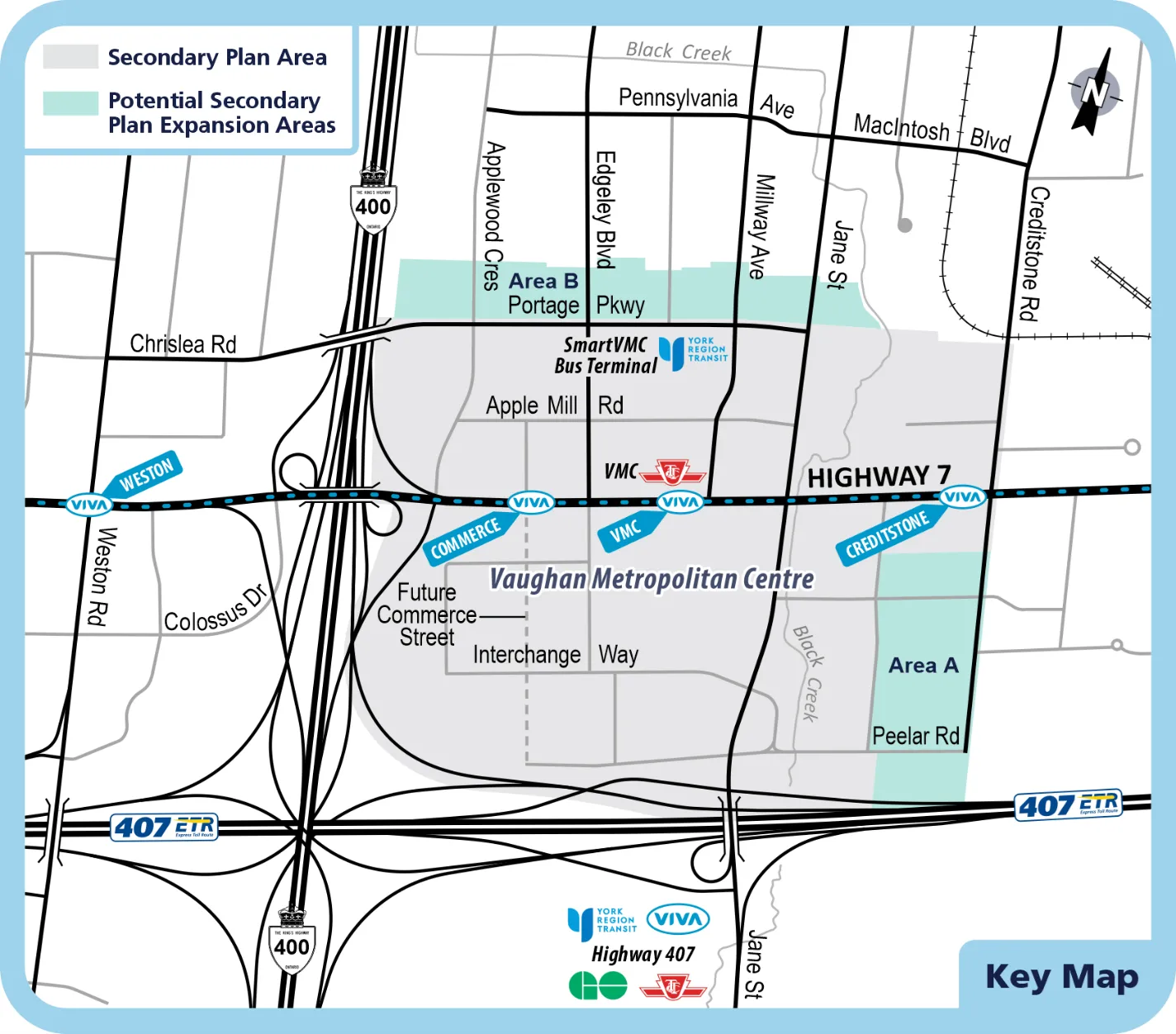
The VMC is supported by a strong road network, including connections to Highway 400 and Highway 407, as well as regional roads (Highway 7, Jane Street) and city collector roads (Edgeley Boulevard, Creditstone Road, Portage Parkway and Interchange Way). As well, the City of Vaughan is the only urban growth centre in the Greater Toronto Area, outside of Toronto, that has subway access and an award-winning intermodal transit system. Viva, York Region Transit’s (YRT) rapid transit service network, operates on Highway 7, the SmartVMC Bus Terminal is serviced by several YRT routes and the VMC TTC subway station provides a crucial connection to downtown Toronto via the York-Spadina line.
Modes of transportation alternative to vehicles are strongly supported throughout the VMC, including separated cycling facilities and high-quality pedestrian spaces that have already been implemented on Apple Mill Road and Millway Avenue to ensure safe and efficient travel options for pedestrian and cyclists, especially in the area close to the TTC and YRT bus terminal.
VMC Transportation Master Plan
The VMC Transportation Master Plan will confirm transportation needs, supportive policies and a phasing strategy to 2041 with a focus on street connectivity, accessibility and support for multi-modal mobility, including walking, biking, public transit and ridesharing.
There has been a long history for the planning of the VMC. The original VMC Plan Review began in 2008 under Vaughan Tomorrow (PDF), the City’s growth management strategy, and the final VMC Secondary Plan (PDF) which formed part of Volume 2 of the Vaughan Official Plan 2010 (as partially approved by the Ontario Municipal Board – December 2019).
Through these plans and based on predicted growth, the City envisions a downtown that is:
transit-oriented, with the highest population density around subway, Viva and bus stations.
walkable, with a safe, easy-to-navigate street network, appealing streetscape, parks and open spaces and mixed-use areas.
accessible, allowing for easy access by transit, vehicle, bicycle and other modes of transportation.
diverse, with a variety of housing options (including affordable), architecture, jobs and open spaces.
vibrant, with ground-floor commercial spaces and civic, cultural, community and institutional destinations.
green, with high green-building standards, efficient energy materials and natural features.
beautiful, with high architectural standards, signature open spaces, public art and natural shade.
The VMC Transportation Master Plan will follow the planning process and satisfy Phases 1 and 2 of the Municipal Class Environmental Assessment (MCEA) process, including an assessment of existing and future conditions, confirmation of transportation needs, and an evaluation of multi-modal transportation network options, all in consultation with regulatory agencies and the public. At the end of the Study, the TMP, which documents the process and plan including transportation infrastructure requirements and multi-modal network recommendations will be available for public review and information.
Schedule ‘C’ Class Environmental Assessment (EA) Studies for the Extensions of Interchange Way and Millway Avenue
In addition to the Vaughan Metropolitan Centre (VMC) Transportation Master Plan, two Schedule ‘C’ Municipal Class Environmental Assessment (MCEA) Studies for the extensions of Millway Avenue and Interchange Way have been carried out:
- Millway Avenue, from Highway 7 to Interchange Way (east-west)
- Interchange Way, from Commerce Street to Creditstone Road
This MCEA process followed the planning and design process for Schedule ‘C’ projects as described in the MCEA Document (October 2000 as amended in 2007, 2011, 2015, and 2023), which is an approved process under the Ontario Environmental Assessment Act.
The proposed extensions of Millway Avenue and Interchange Way were the last two significant missing road segments in the completion of the major collector road network within the VMC. The need for the extensions of these roadways was already established in the original VMC Transportation Master Plan in 2012 and the timing of it has been confirmed through the VMC TMP.
The studies have followed the Class Environmental Assessment process to confirm needs, evaluate alternative designs and select a preferred design, examine impacts on the surrounding environment and identify measures to mitigate those impacts. We have completed the studies and two Environmental Study Reports, which document the decision-making process are available.
Related studies
The VMC Secondary Plan, under a fully integrated and holistic approach to transportation and land use planning.
The VMC Parks and Wayfinding Master Plan will guide the timely development of parks and open spaces in the VMC and create a world-class public area. It also includes the creation of a signage strategy to make it easier to navigate Vaughan's new downtown and presents a rare opportunity to think boldly about the city, the way people understand and move through it, and the role of parks and open space in modern urban life.
Contact
James Norris, P.Eng.
City of Vaughan, Development Engineering Lead
905-832-8585, ext. 8557
Noon Ferdous, P.Eng.
City of Vaughan, Transportation Project Manager (VMC)
905-832-8585, ext. 8605