Weston Road and Highway 7 FAQ
Frequently Asked Questions
-
Answer
A Secondary Plan is a planning document that establishes the policy context and implementation framework for the growth and development of a study area. The planning process is comprehensive, taking into consideration provincial, regional and municipal policy frameworks. It looks at the local context, appropriate levels of growth and development, environmental features, the transportation network, community services and facilities, servicing and infrastructure needs and urban design. Once approved the Secondary Plan will become part of the City of Vaughan Official Plan.
-
Answer
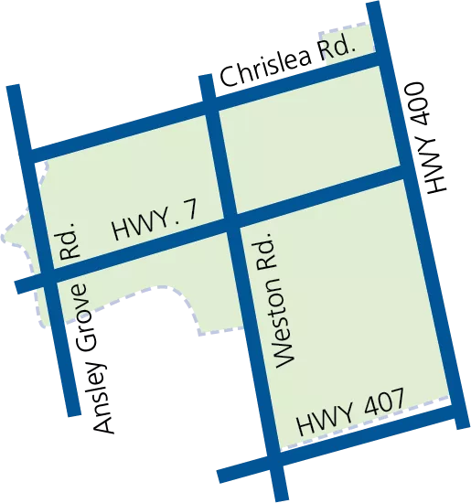
The 129-hectare area surrounding the Weston Road and Highway 7 intersection is the study area. It is bounded by Fieldstone Drive and Portage Parkway to the north, the Highway 400 corridor to the east, the Highway 407 corridor to the south, and Ansley Grove Road/Whitmore Road to the west. The study area is located immediately to the west of the Vaughan Metropolitan Centre (VMC), the City’s downtown.
-
Answer
The study area is one of the City’s strategic growth areas. Positioned adjacent to Highway 400, and immediately west of the VMC, the Weston 7 area is classified as a Primary Centre in the Vaughan Official Plan, 2010. It is intended to become an urban destination that is connected and sustainable, and a mixed-use community that is transit-oriented, pedestrian-friendly and a distinct place of major activity. The Weston 7 study area is one of the City’s greatest opportunities for growth and redevelopment.
The vision for Weston Road and Highway 7 is to help realize the transformation of the area into a dynamic and connected urban centre with access to housing options, retail, community services and facilities, jobs and recreation – that is connected to transit. The future of Weston Road and Highway 7 is a welcoming and vibrant place to work, raise families, access an array of amenities, and enjoy a quality of life that is second to none.
-
Answer
The Vaughan Official Plan, 2010 identifies Primary Centres as locations for intensification, places where rapid transit services intersect with nodes of retail and commercial development, and where there is high redevelopment potential for mixed use transit-oriented development.
-
Answer
The City of Vaughan is focused on urban growth that reflects the needs and desires of the community, balanced with opportunities for continued growth and intensification. The City is committed to an urban transformation that creates more complete, connected, walkable and sustainable communities. To effectively plan for the long-term future of Weston 7, the City of Vaughan has initiated a Secondary Plan Process.
The Weston 7 Secondary Plan process is a three-phase study that will create a strategy to define all the elements needed for successful growth: opportunities for housing and jobs, new roads and active transportation routes, new open spaces and parks, public amenities, and community services and facilities. The Secondary Plan policies will establish appropriate heights and densities for new development, direction for urban design and built form, and hard and soft infrastructure requirements. The final Secondary Plan will formally guide the redevelopment and transformation of Weston 7.
-
Answer
Civic participation is fundamental for understanding the evolving needs and desires of the growing community, and public consultation is an important driver in the city-building process. The City of Vaughan values the views and opinions of its citizens and stakeholders. The City is committed to consulting with the community and providing opportunities for collecting meaningful feedback to help inform the Weston 7 Secondary Plan. See ‘Get Involved’ for upcoming public engagement.